Mountaineering, 'Lung Buster', Alps - Haute Route, August 2010
Oxford University Air Squadron
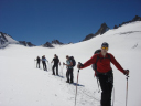
Saturday 31 July: Le Tour to Orny Hut
The weather and views were stunning, and the long walk
provided an excellent opportunity to acclimate ourselves to our ice gear and to
practice the principles that would keep us safe while journeying across ice and
crevasses for the duration of the trip. The gradual ascent became quite steep as
we neared the 3300m col that would serve as our lunch stop. This climb
was a good challenge for the panting teams, and offered a firsthand chance to
experience the difference of exertion at altitude as opposed to sea level.
After lunch, we descended past Cabane du Trient (3170m)
and into the Col dOrny. The rope teams separated from each other, and
were given the opportunity to practice navigation and leadership while
descending over glaciers and then following the winding, rocky path to the Cabane
dOrny (2826m), our home for the night. In total the day involved 10km of
trekking, 1095m of ascent, and 462m of descent.
Sunday 1 August: Orny Hut to Panossiere Hut
The group had been briefed to expect a reasonably easy day,
and this perception was reinforced by the fun and relaxing morning rock
climbing. Consequently, the degree of difficulty of the afternoons walk came
as quite a surprise to some. The path offered an excellent opportunity to
practice navigation and leadership, and involved significant and sometimes steep
periods of ascent intermixed with stretches of rapid descent, often providing
the feeling that little altitude gain progress was being made overall. In this
way, the route up to Cabane FXB-Panossiere (2641m) was both mentally and
physically challenging. In all, the day entailed 1km of lift journey
encompassing 696m of descent and 10km of trekking that included 632m of descent
and 538m ascent.
Monday 2 August: Panossiere Hut to Mauvoisin Hostel
The focus this day was on navigational skills and leadership.
The group split into two smaller teams, and team members were each assigned
responsibility for navigating a specific portion of the route. Before departing,
teams discussed map reading and pathfinding techniques and these skills were
reinforced through practice and continued instruction along the way.
We then ate dinner and retired for the night, hoping that rain
and visibility would clear for our early start and big day the next morning. In
all, our walk to Mauvoisin involved 5.5km trekking, 205m of which was ascent and
1005m descent.
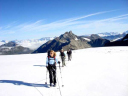
Tuesday 3 August: Mauvoisin Hotel to Dix Hut
We followed a winding dirt track up to the Col de Tsofeiret
(2628m), where we encountered a picturesque lake and herds of cows. The ascent
then became somewhat steeper as we continued to the Col de Lire Rose (3115m) and
broke for lunch en route.
We descended somewhat and crossed a surreal landscape of
enormous boulders, hopping from rock to rock, before reaching our final steep
climb of the day. This rocky and muddy segment led us to the Col de M. Rouge
(3326m), where we caught our breath, affixed our crampons, roped up, and
embarked upon a mushy and crevasse-filled glacier crossing. Once across the
Glacier du Gierto, we reached the Col de Cheilon (3237m) and began the descent
over ice and then along a dirt and rock path to our evenings lodgings: Cabane
des Dix (2928m). The day had involved 15.5km of trekking, 1485m of ascent, and
398m descent.
Wednesday 4 August: Dix Hut to Vignette Hut
This was the day many of us had been most looking forward to:
summiting the Pigne dArolla (3790m), the physical high point of our
trip. In order to make the trek under optimal conditions of crisp snow, we
departed Dix Hut (2928m) early in the morning, having gathered for breakfast at
0515.
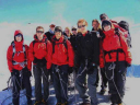
By approximately 1030, both teams had summited the Pigne dArolla
(3790m), taking advantage of the photo opportunity and enjoying the vistas of
the Matterhorn and Mont Blanc.
We grabbed a quick snack just below the summit, then began a
steep, slushy, but speedy descent of about 1.5km to the Cabane des Vignettes
(3160m). Perched on a remote rock and with a helicopter sitting atop its
attached helipad, this hut made for an awesome sight as we approached. We roped
up once more to access it via a rocky ridge, then devoured soup and settled into
our lodgings, congratulating ourselves on a day well done. We had covered 8km of
distance, to include 862m of ascent and 398m of descent.
Thursday 5 August: Vignette Hut to Bertol Hut
After breakfast, we stepped outside to finish donning our kit
and realised that our streak of favourable weather conditions had come to an end
we found ourselves being pelted with snow and socked in with minimal
visibility. Gore-tex and gloves became essential, so after adding these layers
we were then able to set out.
Roped up, we crossed glaciers leading us to the south and east
around Mont Collon. Visibility cleared somewhat and the snow subsided a
bit as we joined (and passed) several other teams following the same route.
The highest of the huts at which wed spend the night, this
facility lacked running water, had primitive toilet facilities, and offered only
mediocre food, but we were happy for the good company and place to sleep, as the
amount of snow falling outside increased, wind picked up, and visibility
lessened.
That evening, we conducted a group de-brief, during which
members could reflect upon their strengths and weaknesses and provide feedback
to the rest of the group. This opportunity for open and honest dialogue
certainly facilitated self-improvement as a leader, follower, and peer
participant and allowed individuals to come away from the trip with a sense
of personal growth and earmarked areas to improve. In a nod to the worsening
weather conditions outside, Stu led a discussion about emergency planning and
mountain safety, which was hugely informative for the group. We then went to
bed, fingers crossed for improved weather, having trekked 13km, ascended 1023m
and descended 801m that day.
Friday 6 August: Bertol Hut to Arolla
The decision was disappointing, but we had no choice: weather
conditions on the morning of the 6th made it unsafe to continue on to Zermatt.
Fresh snow combined with poor visibility meant that the hazard posed by
crevasses was particularly high, and that navigation would be extremely
challenging and thus time consuming, leaving us insufficient hours of daylight
to make the final push to the end of the Haute Route. Not a single team was
departing the Bertol Hut for Zermatt that day, and the only group to have
attempted the route was forced to turn back.
Though our group wanted badly to finish, these circumstances
provided a valuable lesson in safety, prudence, and contingency planning, and
left us all alive and healthy to attempt the route again another day.
Therefore, we roped up and retraced our steps down the rock
supporting the hut and over the Glacier de Bertol. There, we picked up
the path down to Arolla, trekking 6km and losing 1343m of altitude. Once there,
we perched at an outdoor cafe for refreshments and browsed around town while
waiting for the taxi back to Chamonix.
In Chamonix, we immediately sorted kit so that it was all
accounted for and would be ready to return to stores immediately upon our
arrival at Benson. Afterwards, we cleaned up, enjoyed a hearty and relaxing
dinner and celebrated our achievements as a team with an enjoyable night of
socialising and dancing. In total, we had trekked 68km (42miles), gained 5208m
of height, lost 5342m, and proven our ability to push ourselves, utilise
technical skills, and work together as a team.
Oxford University Air Squadron would like to thank all
agencies that made this expedition viable. Special thanks go to The Ulysses
Trust for their kind donation that enabled 10 Officer Cadets to embark on this
life changing journey.
Thanks to
|
 |
working in
partnership with
|
 |
|